





Rising Seas Are Gobbling Up Beaches Around the World. A.I. Might Restore Them.
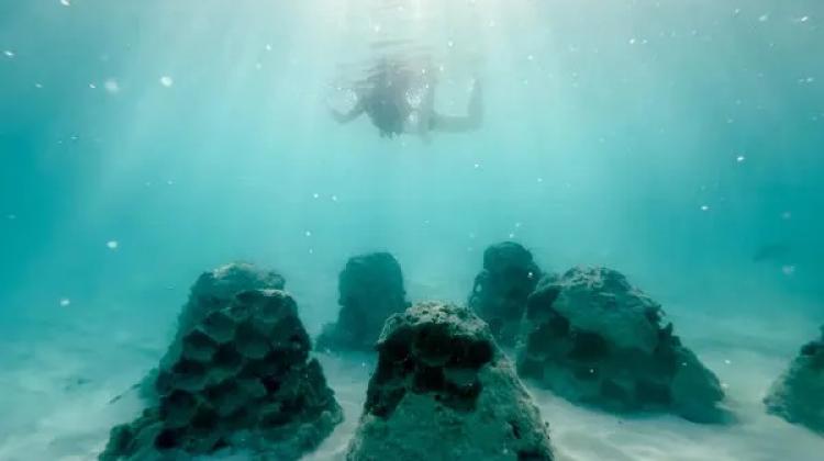
A project uses artificial intelligence and satellite data to design and place underwater structures that harness currents to build the beach back. Credit: Coastal Assembly.
An experiment with roots at M.I.T. used A.l. and satellite images to grow a coastline in the Maldives. More projects are planned for Boston and Miami.
By Quinn Glabicki (Sept. 16, 2026)
As the world's oceans grow ever warmer and the seas rise ever higher, coastlines are retreating at a record pace. And with the rising tides, thousands of coastal communities are at risk. The United Nations warns that as many as 1.2 billion people could be displaced by 2050.
But in the Maldives, a low-lying archipelago in the Indian Ocean, researchers are doing something remarkable: They're growing beaches.
The project, born in a lab at the Massachusetts Institute of Technology a decade ago, uses artificial intelligence, satellite and ocean current data to predict coastal erosion patterns and create submerged structures that harness currents to coax the beach back.
The company, Coastal Assembly, has regrown the sandy shore, extending the beach some 90 feet toward the ocean along a stretch about 300 feet long. A second project built a new sandbar with more than 30,000 cubic feet of sand in just six months, stirring hope that there may be a way to slow the disappearance of coastal societies.
In the turquoise waters off Kaafu Atoll, the company's automated intelligence analyzed 10 years of satellite imagery, currents and other data to predict erosion patterns. Then the company designed and installed 54 structures cast from marine concrete blended with sand and crushed shells, arranged in a row of hexagons. The structure is specially designed to break up eroding waves while allowing the flow of currents that accumulate sand and sediment.
Early results are promising. But perhaps most consequential is the technology that predicts and monitors coastal losses.
Researchers say it has the potential to aid communities in adapting to climate change by reducing the time and cost of complex coastline modeling, and predicting the areas most vulnerable to erosion.
According to a May report from the United Nations, a lack of data and satellite observations has hindered climate adaptation among island nations.
Increased data mapping, a U.N. report in 2026 said, is a "critical foundation" for effective adaptation to climate change.
But the recent boom in satellites and earth-observation technologies, combined with the rapid development of artificial intelligence has made low-cost, automated monitoring and prediction possible, said Skylar Tibbits, one of Coastal Assembly's founders.
"It took us months to do one site in the beginning," Mr. Tibbits said. Site surveying, experimentation, computational simulations and calculations, "everything was by hand." Now, the small team can predict future erosion and develop a plan to address it within a day. They're monitoring erosion patterns in real time at nearly 900 coastal sites using the technology, he said.
"We can go to any community around the world and understand what has happened and then propose a solution that is very precisely tailored to them," Mr. Tibbits said.
So far, the trials have shown promising results. Not only has the beach roughly doubled in size, but new coral has grown on the underwater structures, and fish and other marine wildlife have come to inhabit them, said Srikanth Devarapalli, general manager of the resort that hosts the pilot.
Coastal Assembly spun off from M.I.T. late last year as a public benefit company and had previously received funding from the United States Agency for
International Development and National Geographic before raising several million dollars in venture-backed investment.
Now, the company has 10 more installations set for the Maldives and more projects planned in the Bahamas, Boston Harbor and Miami.
Read more via The New York Times.